


2023 Vanoise J04

Airelle
User
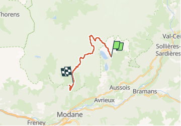

Length
16.4 km

Max alt
2921 m

Uphill gradient
1054 m
Km-Effort
31 km

Min alt
1891 m

Downhill gradient
1319 m
Boucle
No
Creation date :
2022-08-13 09:55:38.402
Updated on :
2023-03-22 19:55:42.746
6h06
Difficulty : Very difficult

FREE GPS app for hiking
 SityTrail
IGN / Geographical institutes
SityTrail Plus
The world is yours!
About
Trail Walking of 16.4 km to be discovered at Auvergne-Rhône-Alpes, Savoy, Aussois. This trail is proposed by Airelle.
Positioning
Country:
France
Region :
Auvergne-Rhône-Alpes
Department/Province :
Savoy
Municipality :
Aussois
Location:
Unknown
Start:(Dec)
Start:(UTM)
321899 ; 5013959 (32T) N.
Comments