


2023 Vanoise J07

Airelle
User
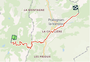

Length
15.1 km

Max alt
2668 m

Uphill gradient
1087 m
Km-Effort
31 km

Min alt
1446 m

Downhill gradient
1353 m
Boucle
No
Creation date :
2022-08-13 10:19:55.404
Updated on :
2023-03-24 17:27:07.935
7h16
Difficulty : Very difficult

FREE GPS app for hiking
 SityTrail
IGN / Geographical institutes
SityTrail Plus
The world is yours!
About
Trail Walking of 15.1 km to be discovered at Auvergne-Rhône-Alpes, Savoy, Courchevel. This trail is proposed by Airelle.
Positioning
Country:
France
Region :
Auvergne-Rhône-Alpes
Department/Province :
Savoy
Municipality :
Courchevel
Location:
Saint-Bon-Tarentaise
Start:(Dec)
Start:(UTM)
316639 ; 5025713 (32T) N.
Comments