


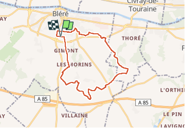
Bléré - Fonds de Bout Ferré - 14.2km 145m 3h30 - 2022 08 15

Orcal37
User GUIDE

Length
14.2 km

Max alt
112 m

Uphill gradient
147 m
Km-Effort
16.2 km

Min alt
64 m

Downhill gradient
147 m
Boucle
Yes
Creation date :
2022-08-15 12:18:09.739
Updated on :
2022-08-16 17:23:22.317
3h30
Difficulty : Easy

FREE GPS app for hiking
 SityTrail
IGN / Geographical institutes
SityTrail Plus
The world is yours!
About
Trail Walking of 14.2 km to be discovered at Centre-Loire Valley, Indre-et-Loire, Bléré. This trail is proposed by Orcal37.
Description
Bléré - Fonds de Bout Ferré - le Vaugerin - 14.2km 145m 3h30 - 2022 08 15
Photos


Positioning
Country:
France
Region :
Centre-Loire Valley
Department/Province :
Indre-et-Loire
Municipality :
Bléré
Location:
Unknown
Start:(Dec)
Start:(UTM)
348254 ; 5242407 (31T) N.
Comments