


Trace Beynat Gourmande

mitch1952
User
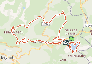

Length
16.2 km

Max alt
564 m

Uphill gradient
359 m
Km-Effort
21 km

Min alt
367 m

Downhill gradient
359 m
Boucle
No
Creation date :
2022-08-14 07:18:27.0
Updated on :
2022-08-15 21:20:57.026
5h54
Difficulty : Unknown

FREE GPS app for hiking
 SityTrail
IGN / Geographical institutes
SityTrail Plus
The world is yours!
About
Trail Walking of 16.2 km to be discovered at New Aquitaine, Corrèze, Beynat. This trail is proposed by mitch1952.
Positioning
Country:
France
Region :
New Aquitaine
Department/Province :
Corrèze
Municipality :
Beynat
Location:
Unknown
Start:(Dec)
Start:(UTM)
402729 ; 4998217 (31T) N.
Comments