


Tour du Mont Rose - Jour 5 -

Michel1963
User GUIDE
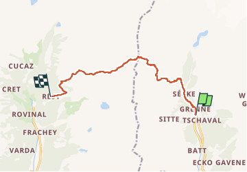

Length
10.5 km

Max alt
2900 m

Uphill gradient
1126 m
Km-Effort
25 km

Min alt
1824 m

Downhill gradient
876 m
Boucle
No
Creation date :
2022-08-18 05:57:57.622
Updated on :
2022-08-18 13:44:31.305
4h39
Difficulty : Difficult

FREE GPS app for hiking
 SityTrail
IGN / Geographical institutes
SityTrail Plus
The world is yours!
About
Trail Walking of 10.5 km to be discovered at Aosta Valley, Unknown, Gressoney-La-Trinité. This trail is proposed by Michel1963.
Positioning
Country:
Italy
Region :
Aosta Valley
Department/Province :
Unknown
Municipality :
Gressoney-La-Trinité
Location:
Unknown
Start:(Dec)
Start:(UTM)
407801 ; 5079114 (32T) N.
Comments