Trail Walking Saint-Maur-des-Fossés - Le sentier de la bataille de Champigny  - Photo

Le sentier de la bataille de Champigny

© OpenStreetMap contributors
Length
Length
17.7 km
Max alt
Max alt
102 m
Uphill gradient
Uphill gradient
201 m
Km-Effort
Km-Effort  
20 km
Min alt
Min alt
32 m
Downhill gradient
Downhill gradient
193 m
Boucle
Boucle
No
Creation date :
2022-08-19 06:19:28.673
Updated on :
2022-08-19 13:41:49.472

(0 Reviews)

Walking
Walking
4h19
Difficulty : Easy

Scan this QR Code to open this trail in the SityTrail application

FREE GPS app for hiking

Logo SityTrail SityTrail

IGN / Geographical institutes

Download SityTrail from the App Store Download SityTrail from Google Play

Logo SityTrail SityTrail World

The world is yours!

Download SityTrail from the App Store Download SityTrail from Google Play Download SityTrail on Huawei AppGallery

About

Trail Walking of 17.7 km to be discovered at Ile-de-France, Val-de-Marne, Saint-Maur-des-Fossés. This trail is proposed by c.chehere.

Description

De la station RER B "Champigny" jusqu'au château de Vincennes M1 en passant par Nogent et la promenade Yvette Horner

Elevation profile

Photos

Positioning

Country:
France
Region :
Ile-de-France
Department/Province :
Val-de-Marne
Municipality :
Saint-Maur-des-Fossés
Location:
Unknown
Start:(UTM)
464087 ; 5406131 (31U) N.

Trails nearby

Trail Walking Neuilly-Plaisance - Neuilly Plaisance gare Rer sortie Bords de Marne/ Base Nautique Vaires sur Marne - Photo
Walking
thierry cachot

Walking

Easy
(1)
Neuilly-Plaisance, Ile-de-France, Seine-Saint-Denis, France
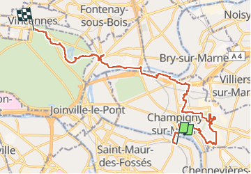
15.9 km | 17.1 km-effort
2h 52min
Yes
Trail Walking Noiseau - depuis Noiseau - Photo
Walking
Bernardroland

Walking

Easy
(2)
Noiseau, Ile-de-France, Val-de-Marne, France
17 km | 19.1 km-effort
4h 35min
Yes
Trail On foot Créteil - JC 84 - La Végétale - 18,2 km - Photo
On foot

On foot

Difficult
(1)
Créteil, Ile-de-France, Val-de-Marne, France
18.3 km | 21 km-effort
4h 40min
No
Trail On foot Sucy-en-Brie - L 08 Sucy en Brie, parc du Morbras - Photo
On foot

On foot

Very easy
(4)
Sucy-en-Brie, Ile-de-France, Val-de-Marne, France
5.7 km | 6.8 km-effort
1h 46min
Yes
Trail On foot Sucy-en-Brie - 8228189-track-1571238544-580 - Photo
On foot
gemau77

On foot

Easy
(1)
Sucy-en-Brie, Ile-de-France, Val-de-Marne, France
10.1 km | 11.3 km-effort
2h 34min
No
Trail Other activity Sucy-en-Brie - Marche - Photo
Other activity
nejman1905

Other activity

Very easy
(1)
Sucy-en-Brie, Ile-de-France, Val-de-Marne, France
15 km | 16 km-effort
3h 15min
No
Trail Walking Nogent-sur-Marne - Autour des Minimes - Photo
Walking
RbK

Walking

Very easy
(2)
Nogent-sur-Marne, Ile-de-France, Val-de-Marne, France
3.7 km | 4.1 km-effort
53min
Yes
Trail Mountain bike Fontenay-sous-Bois - vtt bois de vincennes - Photo
Mountain bike
jknc988

Mountain bike

Medium
(1)
Fontenay-sous-Bois, Ile-de-France, Val-de-Marne, France
38 km | 42 km-effort
1h 59min
Yes
Trail Walking Saint-Maur-des-Fossés - Boucle de la Marne Saint MAUR des Fosses - Photo
Walking
Prala

Walking

Easy
(2)
Saint-Maur-des-Fossés, Ile-de-France, Val-de-Marne, France
13 km | 14.1 km-effort
2h 12min
Yes


Close
My subscriptions