


5 km | 6.4 km-effort

User GUIDE


FREE GPS app for hiking
 SityTrail
IGN / Geographical institutes
SityTrail World
The world is yours!
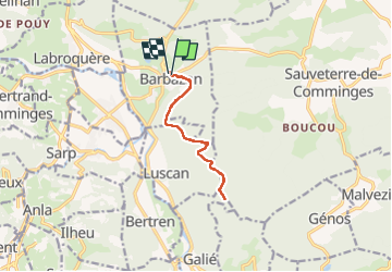
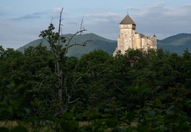
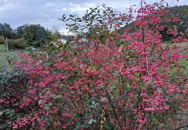
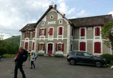
Trail On foot of 11.2 km to be discovered at Occitania, Haute-Garonne, Barbazan. This trail is proposed by marmotte65.
 "
data-pinterest-text="Pin it"
data-tweet-text="share on twitter"
data-facebook-share-url="https://www.sitytrail.com/en/trails/3360313-barbazan--barbazan--le-refuge-saintxmartin-g3-fait-x3360313x/?photo=1#lg=1&slide=1"
data-twitter-share-url="https://www.sitytrail.com/en/trails/3360313-barbazan--barbazan--le-refuge-saintxmartin-g3-fait-x3360313x/?photo=1#lg=1&slide=1"
data-googleplus-share-url="https://www.sitytrail.com/en/trails/3360313-barbazan--barbazan--le-refuge-saintxmartin-g3-fait-x3360313x/?photo=1#lg=1&slide=1"
data-pinterest-share-url="https://www.sitytrail.com/en/trails/3360313-barbazan--barbazan--le-refuge-saintxmartin-g3-fait-x3360313x/?photo=1#lg=1&slide=1">
"
data-pinterest-text="Pin it"
data-tweet-text="share on twitter"
data-facebook-share-url="https://www.sitytrail.com/en/trails/3360313-barbazan--barbazan--le-refuge-saintxmartin-g3-fait-x3360313x/?photo=1#lg=1&slide=1"
data-twitter-share-url="https://www.sitytrail.com/en/trails/3360313-barbazan--barbazan--le-refuge-saintxmartin-g3-fait-x3360313x/?photo=1#lg=1&slide=1"
data-googleplus-share-url="https://www.sitytrail.com/en/trails/3360313-barbazan--barbazan--le-refuge-saintxmartin-g3-fait-x3360313x/?photo=1#lg=1&slide=1"
data-pinterest-share-url="https://www.sitytrail.com/en/trails/3360313-barbazan--barbazan--le-refuge-saintxmartin-g3-fait-x3360313x/?photo=1#lg=1&slide=1">
 "
data-pinterest-text="Pin it"
data-tweet-text="share on twitter"
data-facebook-share-url="https://www.sitytrail.com/en/trails/3360313-barbazan--barbazan--le-refuge-saintxmartin-g3-fait-x3360313x/?photo=2#lg=1&slide=2"
data-twitter-share-url="https://www.sitytrail.com/en/trails/3360313-barbazan--barbazan--le-refuge-saintxmartin-g3-fait-x3360313x/?photo=2#lg=1&slide=2"
data-googleplus-share-url="https://www.sitytrail.com/en/trails/3360313-barbazan--barbazan--le-refuge-saintxmartin-g3-fait-x3360313x/?photo=2#lg=1&slide=2"
data-pinterest-share-url="https://www.sitytrail.com/en/trails/3360313-barbazan--barbazan--le-refuge-saintxmartin-g3-fait-x3360313x/?photo=2#lg=1&slide=2">
"
data-pinterest-text="Pin it"
data-tweet-text="share on twitter"
data-facebook-share-url="https://www.sitytrail.com/en/trails/3360313-barbazan--barbazan--le-refuge-saintxmartin-g3-fait-x3360313x/?photo=2#lg=1&slide=2"
data-twitter-share-url="https://www.sitytrail.com/en/trails/3360313-barbazan--barbazan--le-refuge-saintxmartin-g3-fait-x3360313x/?photo=2#lg=1&slide=2"
data-googleplus-share-url="https://www.sitytrail.com/en/trails/3360313-barbazan--barbazan--le-refuge-saintxmartin-g3-fait-x3360313x/?photo=2#lg=1&slide=2"
data-pinterest-share-url="https://www.sitytrail.com/en/trails/3360313-barbazan--barbazan--le-refuge-saintxmartin-g3-fait-x3360313x/?photo=2#lg=1&slide=2">
 "
data-pinterest-text="Pin it"
data-tweet-text="share on twitter"
data-facebook-share-url="https://www.sitytrail.com/en/trails/3360313-barbazan--barbazan--le-refuge-saintxmartin-g3-fait-x3360313x/?photo=3#lg=1&slide=3"
data-twitter-share-url="https://www.sitytrail.com/en/trails/3360313-barbazan--barbazan--le-refuge-saintxmartin-g3-fait-x3360313x/?photo=3#lg=1&slide=3"
data-googleplus-share-url="https://www.sitytrail.com/en/trails/3360313-barbazan--barbazan--le-refuge-saintxmartin-g3-fait-x3360313x/?photo=3#lg=1&slide=3"
data-pinterest-share-url="https://www.sitytrail.com/en/trails/3360313-barbazan--barbazan--le-refuge-saintxmartin-g3-fait-x3360313x/?photo=3#lg=1&slide=3">
"
data-pinterest-text="Pin it"
data-tweet-text="share on twitter"
data-facebook-share-url="https://www.sitytrail.com/en/trails/3360313-barbazan--barbazan--le-refuge-saintxmartin-g3-fait-x3360313x/?photo=3#lg=1&slide=3"
data-twitter-share-url="https://www.sitytrail.com/en/trails/3360313-barbazan--barbazan--le-refuge-saintxmartin-g3-fait-x3360313x/?photo=3#lg=1&slide=3"
data-googleplus-share-url="https://www.sitytrail.com/en/trails/3360313-barbazan--barbazan--le-refuge-saintxmartin-g3-fait-x3360313x/?photo=3#lg=1&slide=3"
data-pinterest-share-url="https://www.sitytrail.com/en/trails/3360313-barbazan--barbazan--le-refuge-saintxmartin-g3-fait-x3360313x/?photo=3#lg=1&slide=3">
 "
data-pinterest-text="Pin it"
data-tweet-text="share on twitter"
data-facebook-share-url="https://www.sitytrail.com/en/trails/3360313-barbazan--barbazan--le-refuge-saintxmartin-g3-fait-x3360313x/?photo=4#lg=1&slide=4"
data-twitter-share-url="https://www.sitytrail.com/en/trails/3360313-barbazan--barbazan--le-refuge-saintxmartin-g3-fait-x3360313x/?photo=4#lg=1&slide=4"
data-googleplus-share-url="https://www.sitytrail.com/en/trails/3360313-barbazan--barbazan--le-refuge-saintxmartin-g3-fait-x3360313x/?photo=4#lg=1&slide=4"
data-pinterest-share-url="https://www.sitytrail.com/en/trails/3360313-barbazan--barbazan--le-refuge-saintxmartin-g3-fait-x3360313x/?photo=4#lg=1&slide=4">
"
data-pinterest-text="Pin it"
data-tweet-text="share on twitter"
data-facebook-share-url="https://www.sitytrail.com/en/trails/3360313-barbazan--barbazan--le-refuge-saintxmartin-g3-fait-x3360313x/?photo=4#lg=1&slide=4"
data-twitter-share-url="https://www.sitytrail.com/en/trails/3360313-barbazan--barbazan--le-refuge-saintxmartin-g3-fait-x3360313x/?photo=4#lg=1&slide=4"
data-googleplus-share-url="https://www.sitytrail.com/en/trails/3360313-barbazan--barbazan--le-refuge-saintxmartin-g3-fait-x3360313x/?photo=4#lg=1&slide=4"
data-pinterest-share-url="https://www.sitytrail.com/en/trails/3360313-barbazan--barbazan--le-refuge-saintxmartin-g3-fait-x3360313x/?photo=4#lg=1&slide=4">


Walking

Walking

Walking
Walking
Walking
On foot

Mountain bike
Walking
Walking