


L'Absie le Beugnon

taguette
User
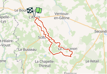

Length
28 km
Boucle
Yes
Creation date :
2022-08-22 07:02:13.23
Updated on :
2022-08-22 13:41:22.484
6h34
Difficulty : Difficult

FREE GPS app for hiking
 SityTrail
IGN / Geographical institutes
SityTrail Plus
The world is yours!
About
Trail Walking of 28 km to be discovered at New Aquitaine, Deux-Sèvres, L'Absie. This trail is proposed by taguette.
Positioning
Country:
France
Region :
New Aquitaine
Department/Province :
Deux-Sèvres
Municipality :
L'Absie
Location:
Unknown
Start:(Dec)
Start:(UTM)
685462 ; 5167180 (30T) N.
Comments