


refuge 1

JPS73
User
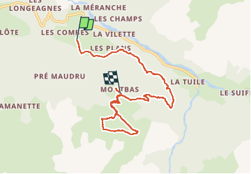

Length
8.5 km

Max alt
2385 m

Uphill gradient
767 m
Km-Effort
17.4 km

Min alt
1689 m

Downhill gradient
388 m
Boucle
No
Creation date :
2022-08-23 06:21:26.199
Updated on :
2022-08-24 13:53:54.653
3h17
Difficulty : Difficult

FREE GPS app for hiking
 SityTrail
IGN / Geographical institutes
SityTrail Plus
The world is yours!
About
Trail Walking of 8.5 km to be discovered at Auvergne-Rhône-Alpes, Savoy, Val-Cenis. This trail is proposed by JPS73.
Positioning
Country:
France
Region :
Auvergne-Rhône-Alpes
Department/Province :
Savoy
Municipality :
Val-Cenis
Location:
Bramans
Start:(Dec)
Start:(UTM)
327665 ; 5009240 (32T) N.
Comments