


foŕlet

jcschubnel
User
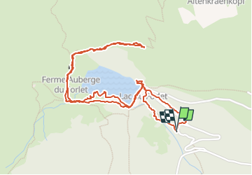

Length
2.9 km

Max alt
1132 m

Uphill gradient
95 m
Km-Effort
4.2 km

Min alt
1028 m

Downhill gradient
99 m
Boucle
Yes
Creation date :
2022-07-28 11:50:07.502
Updated on :
2022-08-29 22:52:52.549
2h38
Difficulty : Easy

FREE GPS app for hiking
 SityTrail
IGN / Geographical institutes
SityTrail Plus
The world is yours!
About
Trail Walking of 2.9 km to be discovered at Grand Est, Haut-Rhin, Soultzeren. This trail is proposed by jcschubnel.
Positioning
Country:
France
Region :
Grand Est
Department/Province :
Haut-Rhin
Municipality :
Soultzeren
Location:
Unknown
Start:(Dec)
Start:(UTM)
357155 ; 5329304 (32U) N.
Comments