


rothenbachkopf

jcschubnel
User

Length
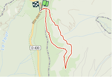
3.5 km

Max alt
1301 m

Uphill gradient
180 m
Km-Effort
5.9 km

Min alt
1136 m

Downhill gradient
180 m
Boucle
Yes
Creation date :
2022-08-02 12:09:01.121
Updated on :
2022-08-29 22:52:55.011
2h45
Difficulty : Easy

FREE GPS app for hiking
 SityTrail
IGN / Geographical institutes
SityTrail Plus
The world is yours!
About
Trail Walking of 3.5 km to be discovered at Grand Est, Haut-Rhin, Wildenstein. This trail is proposed by jcschubnel.
Positioning
Country:
France
Region :
Grand Est
Department/Province :
Haut-Rhin
Municipality :
Wildenstein
Location:
Unknown
Start:(Dec)
Start:(UTM)
349238 ; 5318844 (32U) N.
Comments