


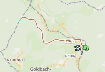
Parking près du Col Amic - Firstacker-Gerstacker-Bieswald-Sattefels et retour

patrickbeyrath
User

Length
8.2 km

Max alt
1156 m

Uphill gradient
308 m
Km-Effort
12.3 km

Min alt
905 m

Downhill gradient
305 m
Boucle
Yes
Creation date :
2022-09-01 06:05:36.081
Updated on :
2022-09-02 05:56:15.305
3h22
Difficulty : Medium

FREE GPS app for hiking
 SityTrail
IGN / Geographical institutes
SityTrail Plus
The world is yours!
About
Trail Walking of 8.2 km to be discovered at Grand Est, Haut-Rhin, Goldbach-Altenbach. This trail is proposed by patrickbeyrath.
Positioning
Country:
France
Region :
Grand Est
Department/Province :
Haut-Rhin
Municipality :
Goldbach-Altenbach
Location:
Unknown
Start:(Dec)
Start:(UTM)
360127 ; 5304750 (32T) N.
Comments