


Blanzac-Pereuil

jmrobin
User
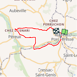

Length
12.1 km

Max alt
153 m

Uphill gradient
168 m
Km-Effort
14.4 km

Min alt
65 m

Downhill gradient
171 m
Boucle
Yes
Creation date :
2019-03-04 10:38:15.579
Updated on :
2019-03-04 10:38:15.611
2h33
Difficulty : Easy

FREE GPS app for hiking
 SityTrail
IGN / Geographical institutes
SityTrail Plus
The world is yours!
About
Trail Walking of 12.1 km to be discovered at New Aquitaine, Charente, Val-des-Vignes. This trail is proposed by jmrobin.
Description
entrée dans blanzac compliquée au retour car circulation et rétrécissements (si rando à cheval)
Positioning
Country:
France
Region :
New Aquitaine
Department/Province :
Charente
Municipality :
Val-des-Vignes
Location:
Péreuil
Start:(Dec)
Start:(UTM)
267752 ; 5039886 (31T) N.
Comments