


Plassac-Becheresse

jmrobin
User
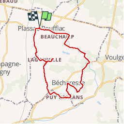

Length
15.6 km

Max alt
188 m

Uphill gradient
272 m
Km-Effort
19.2 km

Min alt
99 m

Downhill gradient
273 m
Boucle
Yes
Creation date :
2019-03-04 10:38:15.226
Updated on :
2019-03-04 10:38:15.257
3h13
Difficulty : Easy

FREE GPS app for hiking
 SityTrail
IGN / Geographical institutes
SityTrail Plus
The world is yours!
About
Trail Walking of 15.6 km to be discovered at New Aquitaine, Charente, Plassac-Rouffiac. This trail is proposed by jmrobin.
Positioning
Country:
France
Region :
New Aquitaine
Department/Province :
Charente
Municipality :
Plassac-Rouffiac
Location:
Unknown
Start:(Dec)
Start:(UTM)
270694 ; 5045758 (31T) N.
Comments