


Tour de Claix - site des meulières

jmrobin
User
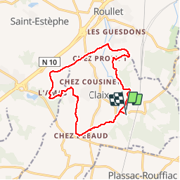

Length
14.3 km

Max alt
135 m

Uphill gradient
255 m
Km-Effort
17.7 km

Min alt
50 m

Downhill gradient
242 m
Boucle
Yes
Creation date :
2019-03-04 10:38:14.847
Updated on :
2019-03-04 10:38:14.886
3h25
Difficulty : Unknown

FREE GPS app for hiking
 SityTrail
IGN / Geographical institutes
SityTrail Plus
The world is yours!
About
Trail Walking of 14.3 km to be discovered at New Aquitaine, Charente, Claix. This trail is proposed by jmrobin.


Positioning
Country:
France
Region :
New Aquitaine
Department/Province :
Charente
Municipality :
Claix
Location:
Unknown
Start:(Dec)
Start:(UTM)
270209 ; 5048069 (31T) N.
Comments