


lac blanc/ plan du lac

geoffrayLayeux
User
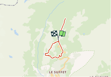

Length
10.1 km

Max alt
2388 m

Uphill gradient
438 m
Km-Effort
16 km

Min alt
2051 m

Downhill gradient
440 m
Boucle
Yes
Creation date :
2022-09-02 07:20:25.939
Updated on :
2022-09-02 07:20:26.837
3h37
Difficulty : Difficult

FREE GPS app for hiking
 SityTrail
IGN / Geographical institutes
SityTrail Plus
The world is yours!
About
Trail Walking of 10.1 km to be discovered at Auvergne-Rhône-Alpes, Savoy, Val-Cenis. This trail is proposed by geoffrayLayeux.
Positioning
Country:
France
Region :
Auvergne-Rhône-Alpes
Department/Province :
Savoy
Municipality :
Val-Cenis
Location:
Termignon
Start:(Dec)
Start:(UTM)
329882 ; 5021747 (32T) N.
Comments