


Thèmes refuge épée par col fenêtre

romoirand
User

Length
8.1 km

Max alt
2860 m

Uphill gradient
1137 m
Km-Effort
21 km

Min alt
1724 m

Downhill gradient
488 m
Boucle
No
Creation date :
2022-09-01 06:17:29.0
Updated on :
2022-09-02 08:46:17.473
5h32
Difficulty : Difficult

FREE GPS app for hiking
 SityTrail
IGN / Geographical institutes
SityTrail Plus
The world is yours!
About
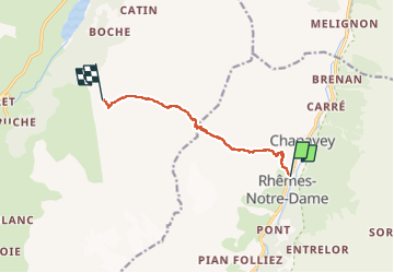
Trail Walking of 8.1 km to be discovered at Aosta Valley, Unknown, Rhêmes-Notre-Dame. This trail is proposed by romoirand.
Description
Bien raide et des passages scabreux
Positioning
Country:
Italy
Region :
Aosta Valley
Department/Province :
Unknown
Municipality :
Rhêmes-Notre-Dame
Location:
Unknown
Start:(Dec)
Start:(UTM)
353238 ; 5048188 (32T) N.
Comments