


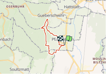
mp pfaffenheim 220803

stempfel52
User GUIDE

Length
9.8 km

Max alt
433 m

Uphill gradient
280 m
Km-Effort
13.5 km

Min alt
212 m

Downhill gradient
280 m
Boucle
Yes
Creation date :
2022-09-03 08:08:35.452
Updated on :
2022-09-03 13:05:02.867
3h03
Difficulty : Difficult

FREE GPS app for hiking
 SityTrail
IGN / Geographical institutes
SityTrail Plus
The world is yours!
About
Trail Walking of 9.8 km to be discovered at Grand Est, Haut-Rhin, Pfaffenheim. This trail is proposed by stempfel52.
Positioning
Country:
France
Region :
Grand Est
Department/Province :
Haut-Rhin
Municipality :
Pfaffenheim
Location:
Unknown
Start:(Dec)
Start:(UTM)
372545 ; 5315604 (32T) N.
Comments