Trail Walking Courgoul - Les-Gorges-de-Courgoul-Marcenat_T - Photo

Les-Gorges-de-Courgoul-Marcenat_T

 force
force

User

© OpenStreetMap contributors
Length
Length
12.7 km
Max alt
Max alt
989 m
Uphill gradient
Uphill gradient
614 m
Km-Effort
Km-Effort  
21 km
Min alt
Min alt
595 m
Downhill gradient
Downhill gradient
611 m
Boucle
Boucle
Yes
Creation date :
2022-09-04 12:19:36.376
Updated on :
2022-09-21 06:59:19.88

(0 Reviews)

Walking
Walking
3h36
Difficulty : Very difficult

Scan this QR Code to open this trail in the SityTrail application

FREE GPS app for hiking

Logo SityTrail SityTrail

IGN / Geographical institutes

Download SityTrail from the App Store Download SityTrail from Google Play

Logo SityTrail SityTrail World

The world is yours!

Download SityTrail from the App Store Download SityTrail from Google Play Download SityTrail on Huawei AppGallery

About

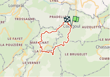
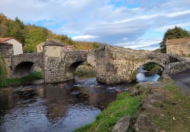
Trail Walking of 12.7 km to be discovered at Auvergne-Rhône-Alpes, Puy-de-Dôme, Courgoul. This trail is proposed by force.

Description

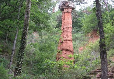
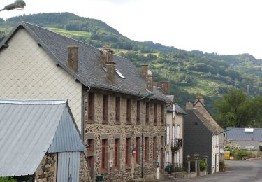
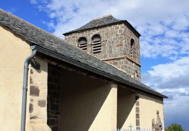
Belle randonnée dans les gorges. Au départ vous pouvez suivre la route dont le tracé suit la Couze ou prendre un sentier qui part du centre du village Courgoule et qui surplombe la couze.
Découvrez Les gorges de Courgoul Marcenat sur Relive! https://www.relive.cc/view/v36A3yEwYZv
Attention les dénivelés sont trop importants, considérez seulement ceux de Sity-Trail !!!

Elevation profile

Photos

Positioning

Country:
France
Region :
Auvergne-Rhône-Alpes
Department/Province :
Puy-de-Dôme
Municipality :
Courgoul
Location:
Unknown
Start:(UTM)
503006 ; 5040028 (31T) N.

Trails nearby

Trail On foot Dauzat-sur-Vodable - Dauzat-sur-Vodable - Photo
On foot
PRO

On foot

Easy
Dauzat-sur-Vodable, Auvergne-Rhône-Alpes, Puy-de-Dôme, France
10 km | 14.7 km-effort
3h 20min
Yes
Trail On foot Saint-Diéry - Le Cheix - Photo
On foot
PRO

On foot

Easy
Saint-Diéry, Auvergne-Rhône-Alpes, Puy-de-Dôme, France
4.8 km | 6.6 km-effort
1h 30min
Yes
Trail On foot Valbeleix - Le Plateau de la Chavade et la Roche Nite - Photo
On foot
PRO

On foot

Medium
Valbeleix, Auvergne-Rhône-Alpes, Puy-de-Dôme, France
15.1 km | 23 km-effort
5h 18min
Yes
Trail On foot Saurier - Le Pic de Brionnet - Photo
On foot
PRO

On foot

Easy
(1)
Saurier, Auvergne-Rhône-Alpes, Puy-de-Dôme, France
4.2 km | 7.8 km-effort
1h 46min
No
Trail Walking Saint-Diéry - St_Diery_Mont_Carmel - Photo
Walking
GUIDE
jagarnier

Walking

Difficult
Saint-Diéry, Auvergne-Rhône-Alpes, Puy-de-Dôme, France
16.8 km | 27 km-effort
5h 0min
Yes
Trail On foot Saint-Diéry - Cotteuge - Photo
On foot
PRO

On foot

Easy
Saint-Diéry, Auvergne-Rhône-Alpes, Puy-de-Dôme, France
7.4 km | 13 km-effort
2h 57min
Yes
Trail On foot Chassagne - Le Plateau d'Ussel - Photo
On foot
PRO

On foot

Easy
Chassagne, Auvergne-Rhône-Alpes, Puy-de-Dôme, France
6.4 km | 9 km-effort
2h 2min
Yes
Trail Walking Saurier - Saurier-Brionnet_T - Photo
Walking
force

Walking

Difficult
Saurier, Auvergne-Rhône-Alpes, Puy-de-Dôme, France
9.5 km | 14.3 km-effort
3h 6min
Yes
Trail Walking Saint-Diéry - Cotteuge_2 - Photo
Walking
GUIDE
jagarnier

Walking

Medium
Saint-Diéry, Auvergne-Rhône-Alpes, Puy-de-Dôme, France
9.3 km | 13 km-effort
2h 45min
Yes


Close
My subscriptions