


G4 Arrette soum de casteigt 2022

LouisROGER
User GUIDE
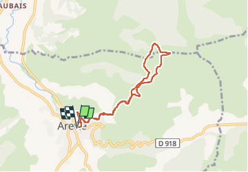

Length
7.7 km

Max alt
575 m

Uphill gradient
270 m
Km-Effort
11.3 km

Min alt
323 m

Downhill gradient
270 m
Boucle
Yes
Creation date :
2022-08-26 08:06:42.513
Updated on :
2022-09-05 09:43:53.387
4h12
Difficulty : Medium

FREE GPS app for hiking
 SityTrail
IGN / Geographical institutes
SityTrail Plus
The world is yours!
About
Trail Walking of 7.7 km to be discovered at New Aquitaine, Pyrénées-Atlantiques, Arette. This trail is proposed by LouisROGER.
Positioning
Country:
France
Region :
New Aquitaine
Department/Province :
Pyrénées-Atlantiques
Municipality :
Arette
Location:
Unknown
Start:(Dec)
Start:(UTM)
685896 ; 4773902 (30T) N.
Comments