


Sentier des maints fonds 22-08-2014

jmrobin
User
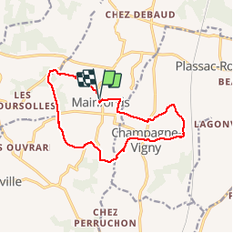

Length
13.3 km

Max alt
149 m

Uphill gradient
246 m
Km-Effort
16.5 km

Min alt
71 m

Downhill gradient
246 m
Boucle
Yes
Creation date :
2019-03-04 10:38:14.436
Updated on :
2019-03-04 10:38:14.467
3h13
Difficulty : Medium

FREE GPS app for hiking
 SityTrail
IGN / Geographical institutes
SityTrail Plus
The world is yours!
About
Trail Walking of 13.3 km to be discovered at New Aquitaine, Charente, Val-des-Vignes. This trail is proposed by jmrobin.


Positioning
Country:
France
Region :
New Aquitaine
Department/Province :
Charente
Municipality :
Val-des-Vignes
Location:
Unknown
Start:(Dec)
Start:(UTM)
267157 ; 5044830 (31T) N.
Comments