


anglet-foret-ustaritz

topolino
User
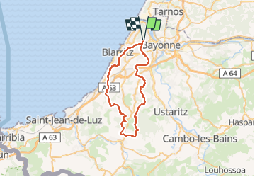

Length
48 km

Max alt
158 m

Uphill gradient
789 m
Km-Effort
59 km

Min alt
4 m

Downhill gradient
786 m
Boucle
Yes
Creation date :
2022-09-10 09:54:19.315
Updated on :
2022-09-10 09:55:34.4
4h04
Difficulty : Very difficult

FREE GPS app for hiking
 SityTrail
IGN / Geographical institutes
SityTrail Plus
The world is yours!
About
Trail Mountain bike of 48 km to be discovered at New Aquitaine, Pyrénées-Atlantiques, Anglet. This trail is proposed by topolino.
Positioning
Country:
France
Region :
New Aquitaine
Department/Province :
Pyrénées-Atlantiques
Municipality :
Anglet
Location:
Unknown
Start:(Dec)
Start:(UTM)
620654 ; 4817350 (30T) N.
Comments