


Formiguère camping Deveze

taguette
User
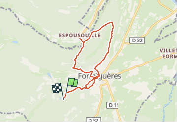

Length
8.3 km

Max alt
1647 m

Uphill gradient
298 m
Km-Effort
12.2 km

Min alt
1508 m

Downhill gradient
290 m
Boucle
Yes
Creation date :
2022-09-11 08:32:58.615
Updated on :
2022-09-11 11:02:21.968
2h27
Difficulty : Easy

FREE GPS app for hiking
 SityTrail
IGN / Geographical institutes
SityTrail Plus
The world is yours!
About
Trail Walking of 8.3 km to be discovered at Occitania, Pyrénées-Orientales, Formiguères. This trail is proposed by taguette.
Positioning
Country:
France
Region :
Occitania
Department/Province :
Pyrénées-Orientales
Municipality :
Formiguères
Location:
Unknown
Start:(Dec)
Start:(UTM)
425456 ; 4717846 (31T) N.
Comments