


carsac Aillac

LouisROGER
User GUIDE
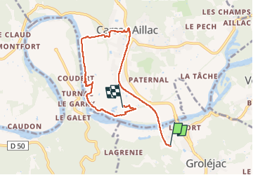

Length
7.3 km

Max alt
108 m

Uphill gradient
85 m
Km-Effort
8.5 km

Min alt
73 m

Downhill gradient
81 m
Boucle
No
Creation date :
2022-09-12 08:00:23.786
Updated on :
2022-09-12 12:47:16.769
4h44
Difficulty : Medium

FREE GPS app for hiking
 SityTrail
IGN / Geographical institutes
SityTrail Plus
The world is yours!
About
Trail Walking of 7.3 km to be discovered at New Aquitaine, Dordogne, Groléjac. This trail is proposed by LouisROGER.
Positioning
Country:
France
Region :
New Aquitaine
Department/Province :
Dordogne
Municipality :
Groléjac
Location:
Unknown
Start:(Dec)
Start:(UTM)
364482 ; 4964461 (31T) N.
Comments