


j2

JPS73
User
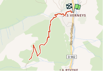

Length
5.3 km

Max alt
1996 m

Uphill gradient
426 m
Km-Effort
11 km

Min alt
1556 m

Downhill gradient
425 m
Boucle
Yes
Creation date :
2022-09-13 12:01:12.709
Updated on :
2022-09-13 15:19:13.936
2h09
Difficulty : Medium

FREE GPS app for hiking
 SityTrail
IGN / Geographical institutes
SityTrail Plus
The world is yours!
About
Trail Walking of 5.3 km to be discovered at Auvergne-Rhône-Alpes, Savoy, Valloire. This trail is proposed by JPS73.
Positioning
Country:
France
Region :
Auvergne-Rhône-Alpes
Department/Province :
Savoy
Municipality :
Valloire
Location:
Unknown
Start:(Dec)
Start:(UTM)
297221 ; 5002728 (32T) N.
Comments