


La combe gâtée

Iahns
User

Length
7.6 km

Max alt
307 m

Uphill gradient
173 m
Km-Effort
9.9 km

Min alt
170 m

Downhill gradient
173 m
Boucle
Yes
Creation date :
2022-09-14 12:58:52.8
Updated on :
2022-09-14 15:20:57.3
2h21
Difficulty : Medium

FREE GPS app for hiking
 SityTrail
IGN / Geographical institutes
SityTrail Plus
The world is yours!
About
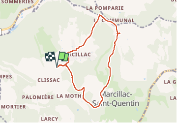
Trail Walking of 7.6 km to be discovered at New Aquitaine, Dordogne, Marcillac-Saint-Quentin. This trail is proposed by Iahns.
Positioning
Country:
France
Region :
New Aquitaine
Department/Province :
Dordogne
Municipality :
Marcillac-Saint-Quentin
Location:
Unknown
Start:(Dec)
Start:(UTM)
357358 ; 4979876 (31T) N.
Comments