


Plat Bolquere barrage Bouillouses

taguette
User
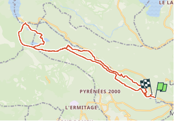

Length
24 km

Max alt
2042 m

Uphill gradient
536 m
Km-Effort
31 km

Min alt
1651 m

Downhill gradient
536 m
Boucle
No
Creation date :
2022-09-15 06:16:43.747
Updated on :
2022-09-15 12:02:49.571
5h37
Difficulty : Difficult

FREE GPS app for hiking
 SityTrail
IGN / Geographical institutes
SityTrail Plus
The world is yours!
About
Trail Walking of 24 km to be discovered at Occitania, Pyrénées-Orientales, La Llagonne. This trail is proposed by taguette.
Positioning
Country:
France
Region :
Occitania
Department/Province :
Pyrénées-Orientales
Municipality :
La Llagonne
Location:
Unknown
Start:(Dec)
Start:(UTM)
425980 ; 4707664 (31T) N.
Comments