Trail Walking Villefranque - MILLAFRANGAN GAINDI - Villefranque  - Photo

MILLAFRANGAN GAINDI - Villefranque

 DECHAMPD
DECHAMPD

User

© OpenStreetMap contributors
Length
Length
12.9 km
Max alt
Max alt
129 m
Uphill gradient
Uphill gradient
390 m
Km-Effort
Km-Effort  
18.1 km
Min alt
Min alt
2 m
Downhill gradient
Downhill gradient
391 m
Boucle
Boucle
Yes
Creation date :
2022-09-15 13:11:47.0
Updated on :
2022-09-16 10:00:52.687

(0 Reviews)

Walking
Walking
3h10
Difficulty : Easy

Scan this QR Code to open this trail in the SityTrail application

FREE GPS app for hiking

Logo SityTrail SityTrail

IGN / Geographical institutes

Download SityTrail from the App Store Download SityTrail from Google Play

Logo SityTrail SityTrail World

The world is yours!

Download SityTrail from the App Store Download SityTrail from Google Play Download SityTrail on Huawei AppGallery

About

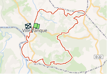
Trail Walking of 12.9 km to be discovered at New Aquitaine, Pyrénées-Atlantiques, Villefranque. This trail is proposed by DECHAMPD.

Description

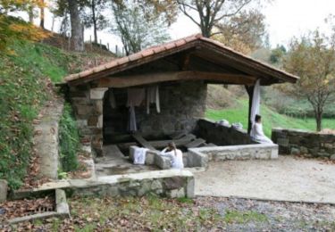
Départ randonnée : Parking des écoles de Villefranque (Pyrénées-Atlantiques 64)
Circuit de 13km depuis le trinquet ou écoles de Villefranque.
Si vous faites ce circuit en mode "trail - course" je vous conseille de partir vers le nord sens de la course.
Sinon pour une randonnée un départ vers le sud est plus approprié.
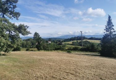
Balade à majorité en campagne entre chemins pistes
et petites routes très peu fréquentées.
cette trace est le parcours du Trail Millafrangan Gaindi depuis 2017.

Elevation profile

Photos

Points of interest

Point of interest Villefranque - PASSAGE??? - Photo
DECHAMPD
VILLEFRANQUE 
Point of interest Villefranque - PASSAGE,,, - Photo
DECHAMPD
VILLEFRANQUE 

Positioning

Country:
France
Region :
New Aquitaine
Department/Province :
Pyrénées-Atlantiques
Municipality :
Villefranque
Location:
Unknown
Start:(UTM)
625167 ; 4810359 (30T) N.

Trails nearby

Trail Walking Mouguerre - La croix de Mouguerre  - Photo
Walking
tracegps

Walking

Easy
(2)
Mouguerre, New Aquitaine, Pyrénées-Atlantiques, France
6.5 km | 8.8 km-effort
1h 45min
Yes
Trail Walking Jatxou - En terre d’Errobi Jatxou - Photo
Walking
DECHAMPD

Walking

Very easy
Jatxou, New Aquitaine, Pyrénées-Atlantiques, France
9.6 km | 13.6 km-effort
2h 41min
Yes
Trail Walking Bayonne - Plaine d'ANSOT Bayonne - Photo
Walking
jaja64

Walking

Easy
Bayonne, New Aquitaine, Pyrénées-Atlantiques, France
8.4 km | 9 km-effort
2h 13min
Yes
Trail Walking Jatxou - Jatxou Hasparren Landes d'Errobi - Photo
Walking
jaja64

Walking

Easy
(1)
Jatxou, New Aquitaine, Pyrénées-Atlantiques, France
10.3 km | 13.9 km-effort
3h 24min
Yes
Trail Mountain bike Ustaritz - Circuit de la Nive - Ustaritz - Photo
Mountain bike
tracegps

Mountain bike

Easy
Ustaritz, New Aquitaine, Pyrénées-Atlantiques, France
10.3 km | 12.1 km-effort
1h 0min
Yes
Trail Walking Ustaritz - Circuit de la Nive - Ustaritz - Photo
Walking
tracegps

Walking

Medium
Ustaritz, New Aquitaine, Pyrénées-Atlantiques, France
10.3 km | 12.1 km-effort
2h 15min
Yes
Trail Walking Saint-Pierre-d'Irube - balade decouverte Mouguerre - Photo
Walking
alex12r

Walking

Difficult
Saint-Pierre-d'Irube, New Aquitaine, Pyrénées-Atlantiques, France
5.7 km | 7.6 km-effort
1h 56min
Yes
Trail Walking Saint-Pierre-d'Irube - Hiru Elizateak Les 3 bornes - Photo
Walking
DECHAMPD

Walking

Very easy
Saint-Pierre-d'Irube, New Aquitaine, Pyrénées-Atlantiques, France
9.1 km | 12.8 km-effort
2h 41min
Yes
Trail Walking Jatxou - Landes entre Jatxou Hasparren - Photo
Walking
DECHAMPD

Walking

Easy
Jatxou, New Aquitaine, Pyrénées-Atlantiques, France
8.9 km | 12.4 km-effort
2h 38min
Yes


Close
My subscriptions