


Angoustrine

taguette
User
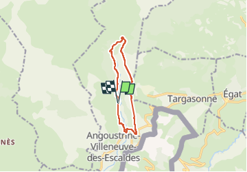

Length
10.3 km

Max alt
1717 m

Uphill gradient
426 m
Km-Effort
16 km

Min alt
1346 m

Downhill gradient
427 m
Boucle
Yes
Creation date :
2022-09-17 06:45:06.378
Updated on :
2022-09-17 09:54:43.615
2h49
Difficulty : Medium

FREE GPS app for hiking
 SityTrail
IGN / Geographical institutes
SityTrail Plus
The world is yours!
About
Trail Walking of 10.3 km to be discovered at Occitania, Pyrénées-Orientales, Angoustrine-Villeneuve-des-Escaldes. This trail is proposed by taguette.
Positioning
Country:
France
Region :
Occitania
Department/Province :
Pyrénées-Orientales
Municipality :
Angoustrine-Villeneuve-des-Escaldes
Location:
Unknown
Start:(Dec)
Start:(UTM)
414513 ; 4705464 (31T) N.
Comments