


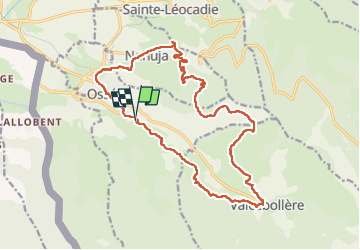
Osseja ardoisières

taguette
User

Length
21 km

Max alt
1856 m

Uphill gradient
779 m
Km-Effort
31 km

Min alt
1236 m

Downhill gradient
768 m
Boucle
Yes
Creation date :
2022-09-18 06:30:33.845
Updated on :
2022-09-18 12:16:17.775
5h40
Difficulty : Difficult

FREE GPS app for hiking
 SityTrail
IGN / Geographical institutes
SityTrail Plus
The world is yours!
About
Trail Walking of 21 km to be discovered at Occitania, Pyrénées-Orientales, Osséja. This trail is proposed by taguette.
Positioning
Country:
France
Region :
Occitania
Department/Province :
Pyrénées-Orientales
Municipality :
Osséja
Location:
Unknown
Start:(Dec)
Start:(UTM)
416975 ; 4695644 (31T) N.
Comments