


Beynac 2022 fait

LouisROGER
User GUIDE
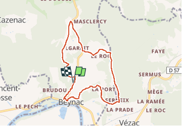

Length
8.2 km

Max alt
222 m

Uphill gradient
260 m
Km-Effort
11.7 km

Min alt
79 m

Downhill gradient
262 m
Boucle
Yes
Creation date :
2022-09-16 07:46:58.33
Updated on :
2022-09-19 08:55:39.133
3h17
Difficulty : Medium

FREE GPS app for hiking
 SityTrail
IGN / Geographical institutes
SityTrail Plus
The world is yours!
About
Trail Walking of 8.2 km to be discovered at New Aquitaine, Dordogne, Beynac-et-Cazenac. This trail is proposed by LouisROGER.
Positioning
Country:
France
Region :
New Aquitaine
Department/Province :
Dordogne
Municipality :
Beynac-et-Cazenac
Location:
Unknown
Start:(Dec)
Start:(UTM)
353418 ; 4967326 (31T) N.
Comments