Trail Walking Esch-sur-Sûre - 2022-09-22_12h36m40_t62751920_eislek pad insenborn - Photo

2022-09-22_12h36m40_t62751920_eislek pad insenborn

© OpenStreetMap contributors
Length
Length
10.2 km
Max alt
Max alt
452 m
Uphill gradient
Uphill gradient
298 m
Km-Effort
Km-Effort  
14.1 km
Min alt
Min alt
322 m
Downhill gradient
Downhill gradient
298 m
Boucle
Boucle
Yes
Creation date :
2022-09-22 10:36:40.114
Updated on :
2022-09-22 10:39:41.542

(0 Reviews)

Walking
Walking
3h12
Difficulty : Medium

Scan this QR Code to open this trail in the SityTrail application

FREE GPS app for hiking

Logo SityTrail SityTrail

IGN / Geographical institutes

Download SityTrail from the App Store Download SityTrail from Google Play

Logo SityTrail SityTrail World

The world is yours!

Download SityTrail from the App Store Download SityTrail from Google Play Download SityTrail on Huawei AppGallery

About

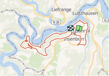
Trail Walking of 10.2 km to be discovered at Unknown, Canton Wiltz, Esch-sur-Sûre. This trail is proposed by mumu.larandonneuse.

Description

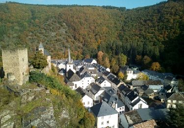
Éislek Pad Insenborn
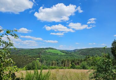
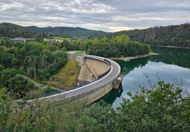
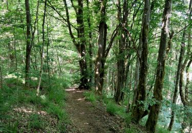
La belle vue

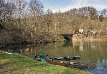
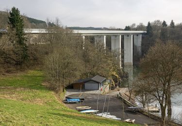
L'eau qui vous accompagne tout le temps lors de cette excursion attirera votre attention - depuis la plage d'Insenborn et surtout à la plate-forme panoramique Belvédère Burfelt. La curiosité et les questions sont les bienvenues au centre de découverte de la forêt. Lors du pique-nique au bord du lac, les personnages en bois sculpté vous tiendront compagnie.

Départ : Parking au centre du village en direction de l'église, Insenborn

Arrivée : Parking au centre du village en direction de l'église, Insenborn

Distance : 10,175 km

Altitude : 424 m

Temps : 03h05

ℹ sur www.visit-eislek.lu

Elevation profile

Positioning

Country:
Luxembourg
Region :
Unknown
Department/Province :
Canton Wiltz
Municipality :
Esch-sur-Sûre
Location:
Unknown
Start:(UTM)
707090 ; 5531578 (31U) N.

Trails nearby

Trail Walking Boulaide - 2023-06-19_14h57m44_eislek-pad-boulaide-1 - Photo
Walking
GUIDE
mumu.larandonneuse

Walking

Difficult
(1)
Boulaide, Unknown, Canton Wiltz, Luxembourg
11.5 km | 16.7 km-effort
3h 48min
Yes
Trail Walking Lac de la Haute-Sûre - 2022-09-22_13h02m46_t62746125_eislek pad bavigne (1) - Photo
Walking
GUIDE
mumu.larandonneuse

Walking

Medium
(1)
Lac de la Haute-Sûre, Unknown, Canton Wiltz, Luxembourg
9.9 km | 13.9 km-effort
3h 9min
Yes
Trail Walking Esch-sur-Sûre - 2023-08-23_09h43m26_circuit-du-lac-partie-est - Photo
Walking
GUIDE
mumu.larandonneuse

Walking

Difficult
(1)
Esch-sur-Sûre, Unknown, Canton Wiltz, Luxembourg
16.8 km | 26 km-effort
5h 53min
Yes
Trail Walking Esch-sur-Sûre - Promenade au lac de la Haute-Sûre   - Photo
Walking
GUIDE+

Walking

Medium
(4)
Esch-sur-Sûre, Unknown, Canton Wiltz, Luxembourg
4.8 km | 7.1 km-effort
1h 36min
Yes
Trail On foot Boulaide - Auto-Pédestre Boulaide 2 - Photo
On foot
GUIDE+

On foot

Easy
Boulaide, Unknown, Canton Wiltz, Luxembourg
7.5 km | 10.5 km-effort
2h 23min
Yes
Trail Walking Esch-sur-Sûre - 2017-10-15 - Photo
Walking
binard

Walking

Medium
(2)
Esch-sur-Sûre, Unknown, Canton Wiltz, Luxembourg
16.3 km | 24 km-effort
5h 4min
No
Trail Walking Lac de la Haute-Sûre - Autopedestres : Liefrange - Photo
Walking
GUIDE+

Walking

Very easy
(1)
Lac de la Haute-Sûre, Unknown, Canton Wiltz, Luxembourg
5 km | 7 km-effort
Unknown
Yes
Trail Walking Lac de la Haute-Sûre - Autopedestres : Bavigne - Photo
Walking
GUIDE+

Walking

Very easy
(2)
Lac de la Haute-Sûre, Unknown, Canton Wiltz, Luxembourg
9.1 km | 12.7 km-effort
Unknown
Yes
Trail On foot Lac de la Haute-Sûre - Fleche Bleu Lifrange - Photo
On foot
GUIDE+

On foot

Easy
Lac de la Haute-Sûre, Unknown, Canton Wiltz, Luxembourg
4.6 km | 6.5 km-effort
1h 28min
Yes


Close
My subscriptions