


Canigou Cortalet los Masos

taguette
User
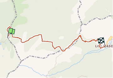

Length
8.2 km

Max alt
2150 m

Uphill gradient
19 m
Km-Effort
12.1 km

Min alt
1040 m

Downhill gradient
1120 m
Boucle
No
Creation date :
2022-09-22 07:05:36.495
Updated on :
2022-09-22 15:26:56.064
2h47
Difficulty : Difficult

FREE GPS app for hiking
 SityTrail
IGN / Geographical institutes
SityTrail Plus
The world is yours!
About
Trail Walking of 8.2 km to be discovered at Occitania, Pyrénées-Orientales, Taurinya. This trail is proposed by taguette.
Positioning
Country:
France
Region :
Occitania
Department/Province :
Pyrénées-Orientales
Municipality :
Taurinya
Location:
Unknown
Start:(Dec)
Start:(UTM)
456116 ; 4709277 (31T) N.
Comments