


Andiran

yoye
User
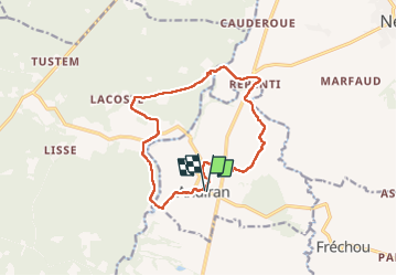

Length
14 km

Max alt
130 m

Uphill gradient
242 m
Km-Effort
17.2 km

Min alt
52 m

Downhill gradient
245 m
Boucle
Yes
Creation date :
2022-09-26 07:43:27.0
Updated on :
2022-09-26 11:55:58.505
3h11
Difficulty : Difficult

FREE GPS app for hiking
 SityTrail
IGN / Geographical institutes
SityTrail Plus
The world is yours!
About
Trail Walking of 14 km to be discovered at New Aquitaine, Lot-et-Garonne, Andiran. This trail is proposed by yoye.
Description
Facile
Positioning
Country:
France
Region :
New Aquitaine
Department/Province :
Lot-et-Garonne
Municipality :
Andiran
Location:
Unknown
Start:(Dec)
Start:(UTM)
282118 ; 4886297 (31T) N.
Comments