


chemin des moulins-Pereuil - 31-08-2014

jmrobin
User
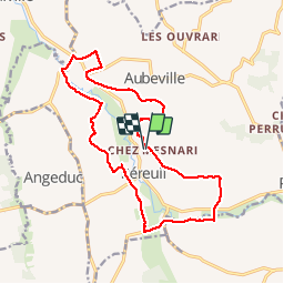

Length
17.3 km

Max alt
131 m

Uphill gradient
271 m
Km-Effort
21 km

Min alt
50 m

Downhill gradient
273 m
Boucle
Yes
Creation date :
2019-03-04 10:38:13.627
Updated on :
2019-03-04 10:38:13.689
3h48
Difficulty : Medium

FREE GPS app for hiking
 SityTrail
IGN / Geographical institutes
SityTrail Plus
The world is yours!
About
Trail Walking of 17.3 km to be discovered at New Aquitaine, Charente, Val-des-Vignes. This trail is proposed by jmrobin.
Description
super pour rando à cheval....et à pied également :-)


Positioning
Country:
France
Region :
New Aquitaine
Department/Province :
Charente
Municipality :
Val-des-Vignes
Location:
Péreuil
Start:(Dec)
Start:(UTM)
732664 ; 5040669 (30T) N.
Comments