


22 10 02 Diedenheim Zillisheim AL RT

jmbilger
User
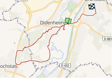

Length
8.6 km

Max alt
341 m

Uphill gradient
179 m
Km-Effort
10.8 km

Min alt
240 m

Downhill gradient
126 m
Boucle
No
Creation date :
2022-10-02 13:32:23.0
Updated on :
2022-10-02 15:24:39.137
1h39
Difficulty : Medium

FREE GPS app for hiking
 SityTrail
IGN / Geographical institutes
SityTrail Plus
The world is yours!
About
Trail Walking of 8.6 km to be discovered at Grand Est, Haut-Rhin, Brunstatt-Didenheim. This trail is proposed by jmbilger.
Positioning
Country:
France
Region :
Grand Est
Department/Province :
Haut-Rhin
Municipality :
Brunstatt-Didenheim
Location:
Brunstatt
Start:(Dec)
Start:(UTM)
373134 ; 5286263 (32T) N.
Comments