


chapelle st Antoine
© OpenStreetMap contributors


3h58
Difficulty : Medium


Length
11.8 km
Max alt
701 m
Uphill gradient
673 m
Km-Effort
21 km
Min alt
199 m
Downhill gradient
672 m
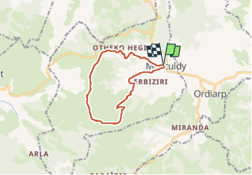
Boucle
Yes
Creation date :
2022-09-20 08:10:44.756
Updated on :
2022-10-03 07:40:58.163
3h58
Difficulty : Medium
FREE GPS app for hiking
 SityTrail
IGN / Geographical institutes
SityTrail Plus
The world is yours!
About
Trail Walking of 11.8 km to be discovered at New Aquitaine, Pyrénées-Atlantiques, Musculdy. This trail is proposed by ChristopheLefauconnier.
Photos


Positioning
Country:
France
Region :
New Aquitaine
Department/Province :
Pyrénées-Atlantiques
Municipality :
Musculdy
Location:
Unknown
Start:(Dec)
Start:(UTM)
665157 ; 4784630 (30T) N.
Comments