


Étangs Minière

Rando MLC
User
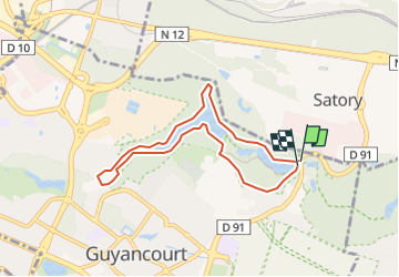

Length
6.6 km

Max alt
162 m

Uphill gradient
93 m
Km-Effort
7.9 km

Min alt
126 m

Downhill gradient
95 m
Boucle
Yes
Creation date :
2022-10-09 07:48:35.582
Updated on :
2022-10-11 09:35:34.459
5h03
Difficulty : Difficult

FREE GPS app for hiking
 SityTrail
IGN / Geographical institutes
SityTrail Plus
The world is yours!
About
Trail Walking of 6.6 km to be discovered at Ile-de-France, Yvelines, Guyancourt. This trail is proposed by Rando MLC.
Positioning
Country:
France
Region :
Ile-de-France
Department/Province :
Yvelines
Municipality :
Guyancourt
Location:
Unknown
Start:(Dec)
Start:(UTM)
433601 ; 5403438 (31U) N.
Comments