


SAPENAY: UNE DE PLUS

djeepee74
User
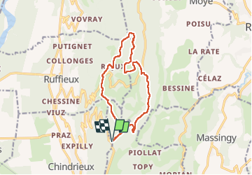

Length
13.7 km

Max alt
1025 m

Uphill gradient
409 m
Km-Effort
19.1 km

Min alt
803 m

Downhill gradient
407 m
Boucle
Yes
Creation date :
2022-10-09 11:35:38.578
Updated on :
2022-10-21 13:35:21.042
3h43
Difficulty : Medium

FREE GPS app for hiking
 SityTrail
IGN / Geographical institutes
SityTrail Plus
The world is yours!
About
Trail Walking of 13.7 km to be discovered at Auvergne-Rhône-Alpes, Savoy, Entrelacs. This trail is proposed by djeepee74.
Description
BOUCLE... live du 20221009
Positioning
Country:
France
Region :
Auvergne-Rhône-Alpes
Department/Province :
Savoy
Municipality :
Entrelacs
Location:
Cessens
Start:(Dec)
Start:(UTM)
722791 ; 5078924 (31T) N.
Comments