


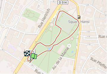
Tour du Champ de Mars

staubalex
User

Length
916 m

Max alt
201 m

Uphill gradient
8 m
Km-Effort
1 km

Min alt
191 m

Downhill gradient
8 m
Boucle
Yes
Creation date :
2022-10-11 17:43:45.0
Updated on :
2022-10-11 17:49:15.269
5m
Difficulty : Unknown

FREE GPS app for hiking
 SityTrail
IGN / Geographical institutes
SityTrail Plus
The world is yours!
About
Trail Other activity of 916 m to be discovered at Grand Est, Haut-Rhin, Colmar. This trail is proposed by staubalex.
Description
Une petite boucle en monocycle
Positioning
Country:
France
Region :
Grand Est
Department/Province :
Haut-Rhin
Municipality :
Colmar
Location:
Unknown
Start:(Dec)
Start:(UTM)
377194 ; 5325943 (32U) N.
Comments