


Trace Angais M2 Guy

mitch1952
User
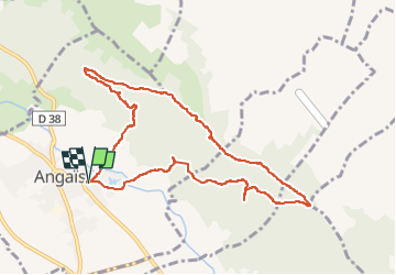

Length
10.3 km

Max alt
420 m

Uphill gradient
269 m
Km-Effort
13.9 km

Min alt
227 m

Downhill gradient
268 m
Boucle
Yes
Creation date :
2022-10-12 17:10:43.513
Updated on :
2022-10-12 17:12:18.994
3h18
Difficulty : Unknown

FREE GPS app for hiking
 SityTrail
IGN / Geographical institutes
SityTrail Plus
The world is yours!
About
Trail Walking of 10.3 km to be discovered at New Aquitaine, Pyrénées-Atlantiques, Angaïs. This trail is proposed by mitch1952.
Positioning
Country:
France
Region :
New Aquitaine
Department/Province :
Pyrénées-Atlantiques
Municipality :
Angaïs
Location:
Unknown
Start:(Dec)
Start:(UTM)
723386 ; 4790806 (30T) N.
Comments