


Tour de la tête de Gaulent et Aiguillas

orsel
User GUIDE
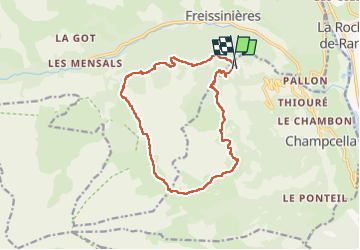

Length
15 km

Max alt
2517 m

Uphill gradient
1002 m
Km-Effort
28 km

Min alt
1621 m

Downhill gradient
1040 m
Boucle
Yes
Creation date :
2022-10-14 07:06:38.06
Updated on :
2022-10-14 19:09:50.76
12h01
Difficulty : Medium

FREE GPS app for hiking
 SityTrail
IGN / Geographical institutes
SityTrail Plus
The world is yours!
About
Trail Walking of 15 km to be discovered at Provence-Alpes-Côte d'Azur, Hautes-Alpes, Champcella. This trail is proposed by orsel.
Positioning
Country:
France
Region :
Provence-Alpes-Côte d'Azur
Department/Province :
Hautes-Alpes
Municipality :
Champcella
Location:
Unknown
Start:(Dec)
Start:(UTM)
305337 ; 4957057 (32T) N.
Comments