


Oltingue Landskron

Alain28/01
User
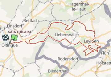

Length
24 km

Max alt
532 m

Uphill gradient
689 m
Km-Effort
33 km

Min alt
329 m

Downhill gradient
689 m
Boucle
Yes
Creation date :
2022-10-17 10:30:00.414
Updated on :
2022-10-17 10:31:23.468
7h36
Difficulty : Very difficult

FREE GPS app for hiking
 SityTrail
IGN / Geographical institutes
SityTrail Plus
The world is yours!
About
Trail Walking of 24 km to be discovered at Grand Est, Haut-Rhin, Oltingue. This trail is proposed by Alain28/01.
Positioning
Country:
France
Region :
Grand Est
Department/Province :
Haut-Rhin
Municipality :
Oltingue
Location:
Unknown
Start:(Dec)
Start:(UTM)
378874 ; 5261040 (32T) N.
Comments