


La Pointe d'Aiguille

Clo0413
User
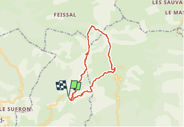

Length
13.8 km

Max alt
1675 m

Uphill gradient
759 m
Km-Effort
24 km

Min alt
1098 m

Downhill gradient
760 m
Boucle
Yes
Creation date :
2022-10-17 06:53:31.022
Updated on :
2022-10-19 06:40:50.313
4h37
Difficulty : Medium

FREE GPS app for hiking
 SityTrail
IGN / Geographical institutes
SityTrail Plus
The world is yours!
About
Trail Walking of 13.8 km to be discovered at Provence-Alpes-Côte d'Azur, Alpes-de-Haute-Provence, Hautes-Duyes. This trail is proposed by Clo0413.
Positioning
Country:
France
Region :
Provence-Alpes-Côte d'Azur
Department/Province :
Alpes-de-Haute-Provence
Municipality :
Hautes-Duyes
Location:
Unknown
Start:(Dec)
Start:(UTM)
274882 ; 4898075 (32T) N.
Comments