


Epannes_fougerit_2

olaze
User
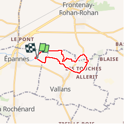

Length
8.8 km

Max alt
28 m

Uphill gradient
41 m
Km-Effort
9.3 km

Min alt
15 m

Downhill gradient
40 m
Boucle
Yes
Creation date :
2014-12-10 00:00:00.0
Updated on :
2014-12-10 00:00:00.0
2h05
Difficulty : Easy

FREE GPS app for hiking
 SityTrail
IGN / Geographical institutes
SityTrail Plus
The world is yours!
About
Trail Walking of 8.8 km to be discovered at New Aquitaine, Deux-Sèvres, Épannes. This trail is proposed by olaze.
Description
Départ & retour du plan d'eau d'Epannes.Dans le marais , la campagne . 09/2014
Positioning
Country:
France
Region :
New Aquitaine
Department/Province :
Deux-Sèvres
Municipality :
Épannes
Location:
Unknown
Start:(Dec)
Start:(UTM)
687402 ; 5122448 (30T) N.
Comments