


Schaffert Hannenbrunenn les 1300

Alain28/01
User
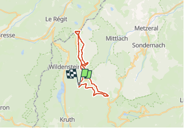

Length
21 km

Max alt
1299 m

Uphill gradient
708 m
Km-Effort
30 km

Min alt
954 m

Downhill gradient
713 m
Boucle
Yes
Creation date :
2022-10-23 15:43:13.406
Updated on :
2023-01-30 15:23:42.52
6h51
Difficulty : Very difficult

FREE GPS app for hiking
 SityTrail
IGN / Geographical institutes
SityTrail Plus
The world is yours!
About
Trail Walking of 21 km to be discovered at Grand Est, Haut-Rhin, Kruth. This trail is proposed by Alain28/01.
Positioning
Country:
France
Region :
Grand Est
Department/Province :
Haut-Rhin
Municipality :
Kruth
Location:
Unknown
Start:(Dec)
Start:(UTM)
349275 ; 5313960 (32T) N.
Comments