


wolschwiller. Lanskron

Alain28/01
User
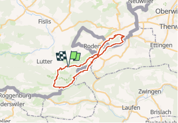

Length
25 km

Max alt
829 m

Uphill gradient
923 m
Km-Effort
38 km

Min alt
384 m

Downhill gradient
924 m
Boucle
Yes
Creation date :
2022-10-20 07:44:18.77
Updated on :
2022-10-23 17:47:45.759
5h43
Difficulty : Very difficult

FREE GPS app for hiking
 SityTrail
IGN / Geographical institutes
SityTrail Plus
The world is yours!
About
Trail Walking of 25 km to be discovered at Grand Est, Haut-Rhin, Wolschwiller. This trail is proposed by Alain28/01.
Positioning
Country:
France
Region :
Grand Est
Department/Province :
Haut-Rhin
Municipality :
Wolschwiller
Location:
Unknown
Start:(Dec)
Start:(UTM)
380551 ; 5257584 (32T) N.
Comments