Trail Walking Helfaut - Rando CAPSO La Coupole - Photo

Rando CAPSO La Coupole

 Yonal62
Yonal62

User

© OpenStreetMap contributors
Length
Length
8.5 km
Max alt
Max alt
98 m
Uphill gradient
Uphill gradient
115 m
Km-Effort
Km-Effort  
10 km
Min alt
Min alt
19 m
Downhill gradient
Downhill gradient
115 m
Boucle
Boucle
Yes
Creation date :
2022-10-25 19:54:00.427
Updated on :
2022-10-25 19:57:02.279

(0 Reviews)

Walking
Walking
2h16
Difficulty : Medium

Scan this QR Code to open this trail in the SityTrail application

FREE GPS app for hiking

Logo SityTrail SityTrail

IGN / Geographical institutes

Download SityTrail from the App Store Download SityTrail from Google Play

Logo SityTrail SityTrail World

The world is yours!

Download SityTrail from the App Store Download SityTrail from Google Play Download SityTrail on Huawei AppGallery

About

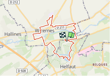
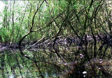
Trail Walking of 8.5 km to be discovered at Hauts-de-France, Pas-de-Calais, Helfaut. This trail is proposed by Yonal62.

Description

La Coupole, les étangs d'Helfaut, Noir Cornet, Cimetière, Papeteries, Centre, Collège, Eglise, Sentier Ste-Claire,

Elevation profile

Positioning

Country:
France
Region :
Hauts-de-France
Department/Province :
Pas-de-Calais
Municipality :
Helfaut
Location:
Unknown
Start:(UTM)
446400 ; 5617401 (31U) N.

Trails nearby

Trail Walking Bellinghem - Inghem - Le sentier des Bosquets - Photo
Walking
tracegps

Walking

Medium
Bellinghem, Hauts-de-France, Pas-de-Calais, France
8.2 km | 9.4 km-effort
1h 45min
Yes
Trail Cycle Ecques - SF 2009 Circuit d'Aire sur la Lys - Photo
Cycle
tracegps

Cycle

Medium
Ecques, Hauts-de-France, Pas-de-Calais, France
130 km | 144 km-effort
5h 57min
Yes
Trail Walking Pihem -  rando du Lion - Photo
Walking
leon65

Walking

Difficult
Pihem, Hauts-de-France, Pas-de-Calais, France
16.3 km | 18.8 km-effort
2h 52min
Yes
Trail Mountain bike Saint-Omer - 2092012 - Photo
Mountain bike
samuel62380

Mountain bike

Medium
Saint-Omer, Hauts-de-France, Pas-de-Calais, France
41 km | 49 km-effort
2h 40min
Yes
Trail Walking Heuringhem - Heuringhem - Le sentier Perdu - Photo
Walking
tracegps

Walking

Medium
Heuringhem, Hauts-de-France, Pas-de-Calais, France
14.5 km | 15.8 km-effort
3h 45min
Yes
Trail Walking Hallines - Le ravin de Pihen 9.8km et 120m déniv - Photo
Walking
eaea7charles

Walking

Medium
Hallines, Hauts-de-France, Pas-de-Calais, France
9.8 km | 11.4 km-effort
2h 35min
Yes
Trail Walking Saint-Martin-lez-Tatinghem - wisques - Photo
Walking
tavaillon

Walking

Easy
Saint-Martin-lez-Tatinghem, Hauts-de-France, Pas-de-Calais, France
6.3 km | 7.3 km-effort
1h 9min
No
Trail Walking Wizernes - Rando 2 Vallées 2022( 23.2Kms Dén P 348m) - Photo
Walking
alain62rando

Walking

Medium
Wizernes, Hauts-de-France, Pas-de-Calais, France
23 km | 28 km-effort
4h 20min
Yes
Trail Walking Wizernes - Rando des 2 Vallées 2022 (17,5Kms Dén P 235m) - Photo
Walking
alain62rando

Walking

Medium
Wizernes, Hauts-de-France, Pas-de-Calais, France
17.5 km | 21 km-effort
4h 40min
Yes


Close
My subscriptions