


Le Vert_ Lestrade et retour

viam19
User
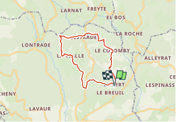

Length
12.3 km

Max alt
901 m

Uphill gradient
386 m
Km-Effort
17.5 km

Min alt
713 m

Downhill gradient
386 m
Boucle
Yes
Creation date :
2022-10-28 21:24:16.465
Updated on :
2022-10-28 21:32:09.59
3h58
Difficulty : Difficult

FREE GPS app for hiking
 SityTrail
IGN / Geographical institutes
SityTrail Plus
The world is yours!
About
Trail Walking of 12.3 km to be discovered at New Aquitaine, Corrèze, Meymac. This trail is proposed by viam19.
Positioning
Country:
France
Region :
New Aquitaine
Department/Province :
Corrèze
Municipality :
Meymac
Location:
Unknown
Start:(Dec)
Start:(UTM)
436329 ; 5045783 (31T) N.
Comments