


GLIERES: PLATEAU - GAUTARD - NOTRE DAME DES NEIGES - LES AUGES - CHEZ LA JODE

djeepee74
User
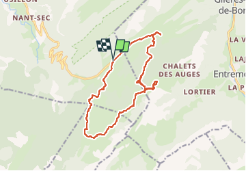

Length
16.2 km

Max alt
1795 m

Uphill gradient
549 m
Km-Effort
24 km

Min alt
1380 m

Downhill gradient
546 m
Boucle
Yes
Creation date :
2022-10-30 08:39:20.257
Updated on :
2022-10-31 14:31:42.644
4h15
Difficulty : Medium

FREE GPS app for hiking
 SityTrail
IGN / Geographical institutes
SityTrail Plus
The world is yours!
About
Trail Walking of 16.2 km to be discovered at Auvergne-Rhône-Alpes, Upper Savoy, Fillière. This trail is proposed by djeepee74.
Description
BOUCLE... live du 20221030

Positioning
Country:
France
Region :
Auvergne-Rhône-Alpes
Department/Province :
Upper Savoy
Municipality :
Fillière
Location:
Thorens-Glières
Start:(Dec)
Start:(UTM)
292832 ; 5093423 (32T) N.
Comments